
খান মোহাম্মদ মৃধা মসজিদ

বর্তমানে বাংলাদেশ সরকারের প্রত্নতত্ত্ব বিভাগ এই মসজিদের রক্ষণাবেক্ষণ করে থাকে।

 কান্তজীউ মন্দির বা কান্তজির মন্দির বা কান্তনগর মন্দির বাংলাদেশের দিনাজপুর শহর থেকে ২০ কিলোমিটার উত্তরে এবং কাহারোল উপজেলা সদর থেকে সাত কিলোমিটার দক্ষিণ-পূর্বে সুন্দরপুর ইউনিয়নে, দিনাজপুর-তেঁতুলিয়া মহাসড়কের পশ্চিমে ঢেঁপা নদীর তীরে অবস্থিত একটি প্রাচীন মন্দির। এটি নবরত্ন মন্দির নামেও পরিচিত কারণ তিনতলাবিশিষ্ট এই মন্দিরের নয়টি চূড়া বা রত্ন ছিলো। কান্তজীউ মন্দির ১৮ শতকে নির্মিত একটি চমৎকার ধর্মীয় স্থাপনা। মন্দিরটি হিন্দু ধর্মের কান্ত বা কৃষ্ণের মন্দির হিসেবে পরিচিত যা লেীকিক রাধা-কৃষ্ণের ধর্মীয় প্রথা হিসেবে বাংলায় প্রচলিত।
 মন্দিরের উত্তর দিকের ভিত্তিবেদীর শিলালিপি থেকে জানা যায়, তৎকালীন দিনাজপুরের মহারাজা জমিদার প্রাণনাথ রায় তাঁর শেষ বয়সে মন্দিরের নির্মাণ কাজ শুরু করেন। ১৭২২ খ্রিস্টাব্দে তাঁর মৃত্যুর পরে তাঁর শেষ ইচ্ছা অনুযায়ী তাঁর পোষ্যপুত্র মহারাজা রামনাথ রায় ১৭৫২ খ্রিস্টাব্দে মন্দিরটির নির্মাণ কাজ শেষ করেন। শুরুতে মন্দিরের চূঁড়ার উচ্চতা ছিলো ৭০ ফুট। ১৮৯৭ খ্রিস্টাব্দে মন্দিরটি ভূমিকম্পের কবলে পড়লে এর চূঁড়াগুলো ভেঙে যায়। মহারাজা গিরিজানাথ মন্দিরের ব্যাপক সংস্কার করলেও মন্দিরের চূড়াগুলো আর সংস্কার করা হয়নি।

 In mid-15th century, a Muslim colony was founded in the unfriendly mangrove forest of the Sundarbans near the coastline in the Bagerhat district by an obscure saint-General, named Khan Jahan Ali. He preached in an affluent city during the reign of Sultan Nasiruddin Mahmud Shah, then known as 'Khalifalabad'. Khan Jahan adorned this city with more than a dozen mosques, the spectacular ruins of which are focused around the most imposing and largest multidomed mosques in Bangladesh, known as the Shait-Gumbad Masjid (160'×108').[2] The construction of the mosque was started in 1442 and it was completed in 1459.The mosque was used for prayer purposes. It was also used as a madrasha and assembly hall.
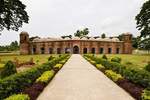


 The 'Sixty Dome' Mosque has walls of unusually thick, tapered brick in the Tughlaq style and a hut-shaped roofline that anticipates later styles. The length of the mosque is 160 feet and width is 108 feet. There are 77 low domes arranged in seven rows of eleven, and one dome on each corner, bringing the total to 81 domes. There are four towers. Two of four towers were used to call azaan. The interior is divided into many aisles and bays by slender columns, which culminate in numerous arches that support the roof.
 The mosque has 77 squat domes with 7 four-sided pitched Bengali domes in the middle row.The vast prayer hall, although provided with 11 arched doorways on east and 7 each on north and south for ventilation and light, presents a dark and somber appearance inside. It is divided into 7 longitudinal aisles and 11 deep bays by a forest of 60 slender stone columns, from which springs rows of endless arches, supporting the domes. Six feet thick, slightly tapering walls and hollow and round, almost detached corner towers, resembling the bastions of fortress, each capped by small rounded cupolas, recall the Tughlaq architecture of Delhi.The mosque represents wonderful archeological beauty which was the signature in the 15th century.
 The excavation at Paharpur, and the finding of seals bearing the inscription Shri-Somapure-Shri-Dharmapaladeva-Mahavihariyarya-bhiksu-sangghasya, has identified the Somapura Mahavihara as built by the second Pala king Dharmapala(circa 781–821) of Pāla Dynasty.[3] Tibetan sources, including Tibetan translations of Dharmakayavidhi and Madhyamaka Ratnapradipa, Taranatha's history and Pag-Sam-Jon-Zang, mention that Dharmapala's successor Devapala (circa 810–850) built it after his conquest of Varendra.[3] The Paharpur pillar inscription bears the mention of 5th regnal year of Devapala's successor Mahendrapala (circa 850–854) along with the name of Bhiksu Ajayagarbha.[3] Taranatha's Pag Sam Jon Zangrecords that the monastery was repaired during the reign of Mahipala (circa 995–1043 AD).[3]
 In acreage, Somapura was the largest of the mahaviharas.[7] Its architecture was unusual. As one scholar described, the complex was dominated by a temple, which was not typical, and further, the temple had "none of the characteristic features of Indian temple architecture, but is strongly reminiscent of Buddhist temples of Burma, Java and Cambodia, reproducing the cruciform basement, terraced structure with inset chambers and gradually dwindling pyramid form ... during the age of the Palas some sort of intercourse between eastern India and south-east Asia existed ... but how this temple type, represented in India by this solitary example, became the standard of Buddhist temple architecture is not known."[8] Another commented, "there can be no doubt that this style of architecture has most profoundly influenced that of Burma, Java and Cambodia. The nearest approximation to the plan and the superstructure of the Paharpur temple is afforded by the temples known as Chandi Loro Jongrang and Chandi Sevu of Prambanam in Central Java.

 Mainamati (Bengali: ময়নামতি Môenamoti) is an isolated low, dimpled range of hills, dotted -with more than 50 ancient Buddhist settlements of the 8th to 12th century A.D. It is extended through the centre of the district of Comilla. Mainamati is located almost 8 miles from the town of Comilla, Bangladesh. It is the home of one of the most important Buddhist archaeological sites in the region. There are a number of Buddhist sites in this region, dating approximately from 7th to 12th centuries CE. to Chittagong.


